To view an index of items regarding Fort Point 100-Acres planning, click here.
To read more about Fort Point's status as a Local Landmark District, click here.
To read a brief history of Fort Point, as presented to Mayor Thomas M. Menino and the Boston Landmarks Commission, click here.To view a related article, click here.
MISSING
8/22/06
BRA Excluding Historic Buildings from Fort Point Maps, Plans
Filmmaker Martin Scorcese was prescient in his use of Fort Point's historic warehouses for the filming of "The Departed". Five existing historic Fort Point buildings have recently departed from BRA maps of "existing buildings".
The Boston Redevelopment Authority is publishing maps of Fort Point's "existing buildings" that have completely excluded two of the five missing historic buildings. A second map places "proposed buildings" on the sites of all five historic buildings. The missing buildings are among the most handsome of the area's industrial-era architectural collection.
No maps are provided for readers of the newly published Fort Point 100 Acre Plan to clarify an actual inventory of existing historic buildings. And no information is provided to readers about the fate of five existing historic buildings, as an explanation of why the parcels on which these buildings are sited are presented as future development sites.
Over past years, members of the Fort Point community have repeatedly asked the BRA to include all existing buildings on maps that present "existing buildings" and to correctly present ownership by small property owners rather than incorrectly attributing small parcels to large property owners.
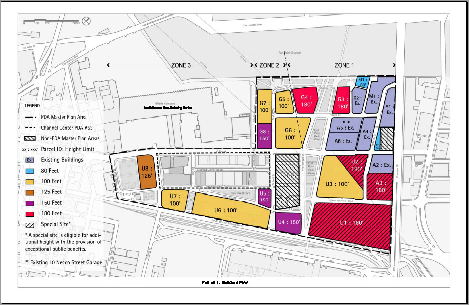
The following map (Exhibit I) appears in the Final Draft 100 Acres PDA Master Plan and Fort Point 100 Acres Plan, identifying "existing buildings". The parcel hilighted in the black circle does not show two historic buildings (319 A Street, rear, and 327-345 Summer St.).
source: BRA 100 Acres PDA Master Plan (click on image above to enlarge map)
Missing Buildings in 100 Acre PDA Master Plan
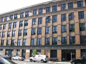
The map above excludes two existing historic buildings on Parcel A3, shown in the photographs below.
MISSING
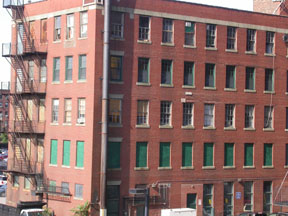
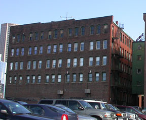
327-345 Summer Street
(corner view)
MISSING
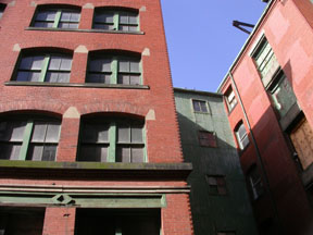
327-345 Summer Street
(front view)
MISSING
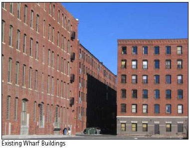
319 A Street Rear Bldg
(southern face view)
MISSING
319 A Street Rear Bldg
(east corner view)
MISSING
319 A Street Rear Bldg
(north face view)
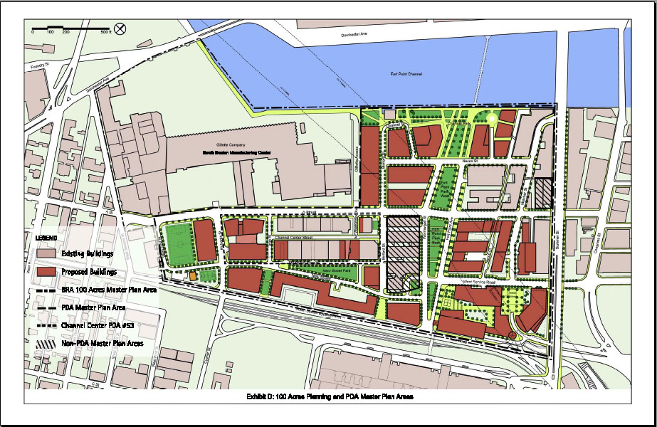
On a second map in the BRA's PDA Master Plan (Exhibit D), "existing buildings" and "proposed buildings" are shown.
source: BRA 100 Acres PDA Master Plan (click on image above to enlarge map)
In the above map, the "existing building" sites do not include five existing historic buildings on the sites shown in black circles. Instead, these sites are labeled as "proposed buildings".
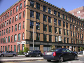
Shown below are the historic buildings that actually exist on the above "proposed" sites (in addition to the buildings shown earlier on this page).These buildings include the original Necco factory.
MISSING
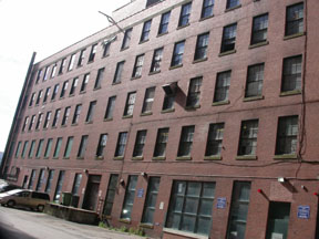
Necco Street / Front Bldg
(east corner view)
MISSING
Necco Street / Rear Bldg
(south face view)
MISSING
Necco Street Bridge
(detail)
MISSING
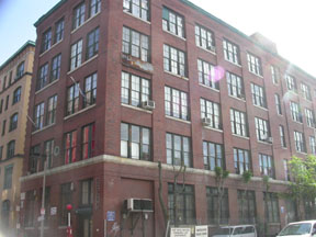
319 A Street
(southwest corner view)
While these three of the five missing buildings (Necco Street front and rear, and 319 A Street) appear on other BRA maps of "existing buildings", no explanation is given as to why these three buildings are listed as "proposed" development sites in Exhibit D.
No maps in either the PDA Master Plan or 100 Acre Plan accurately inventory existing buildings, or provide information about the future of these five historic buildings.
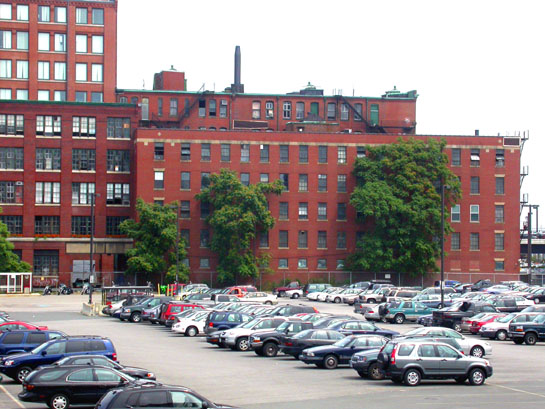
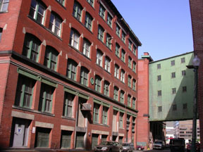
Ironically (as shown below), photographs of two of the buildings that are missing from "existing buildings" maps and plans appear in the 100 Acre plan to demonstrate the character of the existing historic district.
MISSING
Necco Street Rear (at right of image)This photograph is from the BRA 100-Acre Plan, used to demonstrate the character of the historic district. The 100 Acre Plan excludes the building on the right from a map of "existing buildings".
source: 100 Acre Plan
click on image to enlargeMISSING
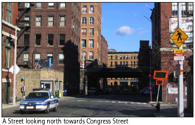
319 A Street (at right of image)This photograph is from the BRA 100-Acre Plan, used to demonstrate the character of the historic district. The 100 Acre Plan excludes the building on the right from a map of "existing buildings".
source: 100 Acre Plan
click on image to enlargeWhile the BRA may have envisioned the eventual demolition of these and other historic buildings, all existing buildings should have be included on a map of "existing buildings"-- especially given the diligent and perpetual calls from the community for accurate recognition of Fort Point's important historic collection. Context and correct information is critically important to others, including the Boston Landmarks Commission now considering a petition for Local Landmark District designation.
Your comments as a visitor to the SAND website would be appreciated and forwarded for discussion.