To view an index of items regarding Fort Point 100-Acres planning, click here.
To read more about Fort Point's status as a Local Landmark District, click here.
To read a brief history of Fort Point, as presented to Mayor Thomas M. Menino and the Boston Landmarks Commission, click here.To view a related article, click here.
8/11/06
Fort Point "Historic" losing its identification in BRA Maps and Plans
Within past months, the Boston Redevelopment Authority has quietly and systematically redacted City maps and plans to remove the word "Historic" from Fort Point and its nationally recognized historic subdistricts. These revisions coincide with recent BRA reversals of longstanding planning policy, now supporting modern multi-story additions to Fort Point's historic collection of industrial-age wharf buildings.
In 2001, the Boston Landmarks Commission voted in a unanimous decision that Fort Point was worthy of consideration as a Boston Local Landmark District and embarked on further study (research report funded, completed in 2003, designation currently in process).
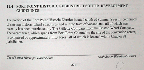
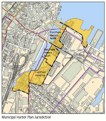
From 2001-2005, the Boston Redevelopment Authority pubicly registered general support for a designation of Fort Point as a Local Landmark District. With the publication of the Boston Redevelopment Authority Municipal Harbor Plan in 2001, BRA planning maps and text identified all Fort Point subdistricts as "Historic", identifying two subdistricts, namely "Fort Point Historic North" and "Fort Point Historic South."
SOURCE: 2001 BRA Municipal Harbor Plan
SOURCE: 2001 BRA Municipal Harbor Plan
SOURCE: 2001 BRA Municipal Harbor Plan
June 2005: The Shrinking of the Historic District Begins
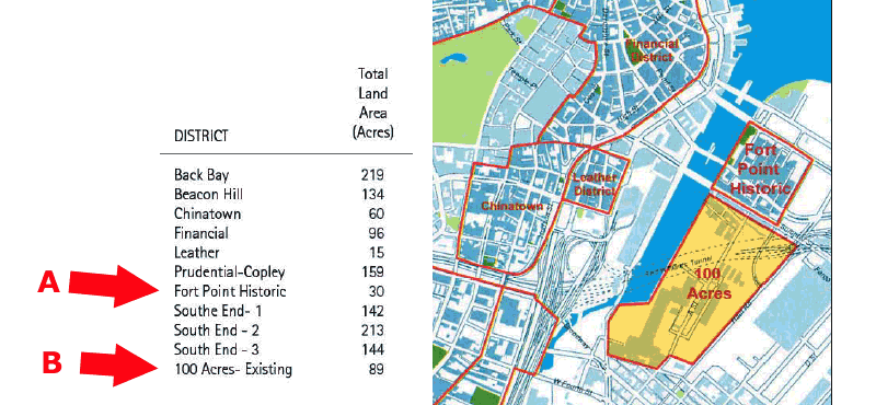
In June 2005, with the publication of its First Draft / 100-Acres Plan, the Boston Redevelopment removed references to the former naming convention "Historic" from City of Boston planning maps and text identifying the area of Fort Point south of Summer Street. This area, formerly identified as "Fort Point Historic South", was renamed as "100 Acres".
This purge of the word "Historic" from the 100-Acre area was not an oversight, since the abutting subdistrict name was also modified to reflect a redaction. That area, formerly identified as "Fort Point Historic North" was renamed simply "Fort Point Historic". With this revision, scores of historic buildings were excluded from their former recognition.
source: Boston Redevelopment Authority 100-Acres Plan Draft / June 2005
A) Area formerly identified as "Fort Point Historic North"
B) Area formerly identified as "Fort Point Historic South"
June 2005 to June 2006: Community repeatedly notifies BRA
Upon the release of the BRA's First Draft 100 Acres Plan in June 2005, the BRA was notified that the purging of the word "historic" from City maps and plans was problematic. In September 2005, the SAND website posted an entire news item on this issue (click here to read).
Upon the release of the BRA's "Revised" Draft 100 Acres Plan in May 2006, the following text was sent in a letter to Mr. Kairos Shen, BRA, Director of Planning:
"2. Removal of the word “Historic” from longstanding area Naming Conventions. Since 2005, despite public protestations, the BRA began to exclude large tracts of Fort Point land and buildings from recognition as part of the Fort Point Historic District. In the 100-Acre plan, most notably on page 78, the BRA refers to the entire area north of Summer Street as the “Fort Point Historic District” and the area south of Summer Street is simply “100 Acres”. From 2000-2005, these areas were accurately referred to in the BRA’s official planning documents as “Fort Point Historic District North” and “Fort Point Historic District South”. The BRA’s 100-Acre plan should continue to respect the historic integrity of the area."
-- Source: BRA, Public Comment Letters on 100 Acres Plan, Hollinger 6/30/2006
August 2006: The BRA Purges all Historic Identifiers
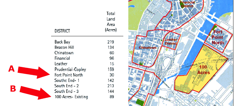
In August 2006, with the publication of its FINAL 100-Acres Plan, the Boston Redevelopment Authority removed all remaining references to the naming convention "Historic" from City of Boston planning maps and text identifying the area of Fort Point north of Summer Street. This area was formerly identified as "Fort Point Historic North" and was remapped as "Fort Point North".
The most unusual observation about this purge, was that the BRA removed the term "Historic" from the name of the "Fort Point North" subdistrict only in the Final Draft 100 Acres Plan (not in the June 2005 First Draft, the May 2006 draft revisions, or during the 5-year period of its planning). Even more unusual was that this renaming occured for the "North" subdistrict despite the fact that the "Fort Point North" area is entirely outside the 100 Acres Plan, its jurisdiction, community process and oversight.
SAND's unanswered questions remain: Who made these changes, and why were they made?
source: Boston Redevelopment Authority 100-Acres Plan FINAL / August 2006
A) Area formerly identifed as "Fort Point Historic North"
B) Area formerly identified as "Fort Point Historic South"
Your comments as a visitor to the SAND website would be appreciated and forwarded for discussion.